
We are off track; walking the
New England escarpment to Darkie Point. Nests of light settle on the forest
floor having broken through a closely woven canopy of Antarctic beech trees
which tower above us. Then low cloud streams in. The light freezes mid
air, forming thick golden shards that angle against our compass bearing. Ahead,
the forest slopes towards the escarpment's cliff line. A prevailing wind
drags mist out of the valley below and whips it up the rock face. The air is so dense with moisture it is caught on leaves and
branches and drips, drips, drips as if it were raining.
This is the cloud forest at work:
the manifestation of a landscape shaped in such a way, located in such a place,
as to draw in and create its own cycle of wild weather that keeps this cool
temperate rainforest constantly supplied with water.
A few million years in the
making, the New England escarpment and its deep green rainforests are part of Australia's World Heritage listed landscape and are
protected in the vast surrounds of New England National Park, located
85km east of Armidale or 75km west of Dorrigo in northern NSW.


We begin our walk at Point Lookout, the main visitor access point in the park. At 1563 metres above sea level its rocky prow juts over the Thora Valley and the New England wilderness. On clear days the ocean and coastline are easily visible from this point, but today heavy patches of cloud obscure much of the view. We can still make out the escarpment, a distinct edge of cliffs topped with thick forest, all the way to Darkie Point (Nguloongeer) where we hope to spend the night.
The first part of our walk
is straightforward, initially on the access road to some communication towers
behind Point Lookout. Beyond that we follow the faint remnants of an old track
that hugs the escarpment and gives us great views down into the headwaters of
the Bellinger River. We zig-zag our way following fencelines and service roads
along the western boundary of the national park. While this route leads us
inland and away from the views it is easy going compared to the escarpment edge
which in parts is a thick tangle of pepperbush and supplejack vines. We rejoin the views a couple of kilometres on, at a wide grassy saddle
where farmland comes right to the cliff edge and once again we are looking over
the vast wilderness that spreads out beneath the plateau.


Darkie Point is looming closer. It is an impressive, multi-tiered promontory whose title hints at the sort of dark history hidden behind many of Australia's strangely named places. Darkie Point is a place of massacre. Despite its spectacular beauty, it's story is one of dispossession and war and ugly murder.


Darkie Point is looming closer. It is an impressive, multi-tiered promontory whose title hints at the sort of dark history hidden behind many of Australia's strangely named places. Darkie Point is a place of massacre. Despite its spectacular beauty, it's story is one of dispossession and war and ugly murder.
The massacre here took place in
1841 when squatters and settlers pursued a group of approximately 200
aboriginals who had killed three local shepherds and made off with 2000 head of
sheep. In a rare example of colonial account keeping the squatter who owned the
stolen sheep wrote a florid eyewitness account of the days spent hunting the group and also details of the ensuing massacre. His account tells of their surprise attack on the aboriginals, the continuous gunfire, and the terror and confusion that forced those not shot over the cliffs, jumping to their deaths.
By the end, even the squatter complains he was "sick of the horrid carnage
below" and yet those around him continued shooting.
Today, all over Australia, there are few visible reminders, few memorials at massacre sites, and we tend to not publicly acknowledge the brutal aspects of our settler history. As we walk closer and closer to Darkie Point I wonder at how it will feel walking over that ground, admiring the view, with this story on board.
Today, all over Australia, there are few visible reminders, few memorials at massacre sites, and we tend to not publicly acknowledge the brutal aspects of our settler history. As we walk closer and closer to Darkie Point I wonder at how it will feel walking over that ground, admiring the view, with this story on board.


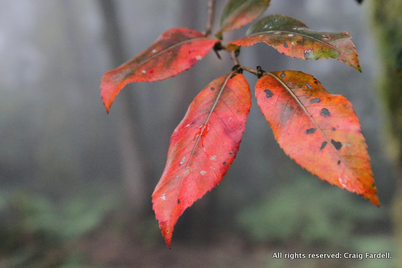
And despite its history, Darkie Point is one of the most physically beautiful places I have encountered. When we reach its furthermost point, we slipper our tent amongst the close trunks of mountain tea tree. Chill with quiet, thin cloud sweeps across the broken line of escarpment so that we find ourselves drifting in and out of white skies and blue. Behind where we camp, a thick pelt of green moss covers the trees and rocks and branches hang with old man’s beard. A startled lyre bird breaks the silence with a piercing alarm call. A yellow robin flits in, hangs sideways on a tree trunk and watches as we boil water for a cup of tea.
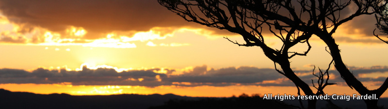
The trees on the point are stunted from fierce and cold prevailing winds, so our heads are practically in the canopy and we get down on all fours to crawl out onto a rocky view point. Above us, a wedge tail eagle emerges from the white cloud, so close we hear the wind whistling its wings. When the drifting clouds finally part we get views down onto the rainforest canopy hundreds of metres below. Across the head of the scooped, amphitheater-like valley we can see the boney profile of Point Lookout where we began our walk. There is an uncanny degree of peace and quiet as the evening sun dips beneath the cloud and warm orange light paints trunks and grass and rocks.

In the morning we slowly pack up and begin walking again, east along the escarpment and heading for Majors Point, the next significant outcrop on this rugged edge. We stick close to the escarpment this time as the cool temperate rainforest is easy to walk through but the cloud forest is back and we are at its mercy. Wind-whipped moisture streams through the canopy and it becomes progressively wetter and wetter until fat drops of water begin falling. We are forced to put on our rain jackets, even though it isn't raining.
Before reaching Majors Point we
dip into a steep gully where a tiny, crystal clear stream trickles over
slick black rocks. Consulting our map we discover this is the head of the great
Guy Fawkes River and that it continues about 8km west across the tablelands to the
town of Ebor where it drops in a spectacular waterfall before continuing to
wend its way for 45km through Guy Fawkes River National Park. It is an exciting
moment to see the tiny origins of a river which we have walked along at its more expansive end where it spreads out in wide gravel beds and deeps pools.


At Majors Point we find the
increasing cloud more persistent and there are no views on offer. Bright yellow
paper daisies shelter beneath the rocky summit where a trig marker lays broken
on the ground. The wind is stronger and cold. More cool temperate rainforest
lies beneath the point but behind us we find the old vehicle track that leads
through snow grass and snow gums towards our end point. Majors Point is
accessible to the public but the road is across private property and contact
with the owners is advised, out of respect, and also for advice on following
the slightly indistinct network of tracks and gates. The owners contact
details are available from National Parks and Wildlife. It is roughly 30km by
road from Majors Point back to Point Lookout.
Another option, of course, is to
simply turn around and walk back to Point Lookout and discover new views and enjoy the stunning forest again on the return journey.
It's always good to see a landscape from as many sides as you can, especially one as multi-faceted as the New England Escarpment. It's also worth exploring the cloud forest of
history, the white obscuring mist that shrouds so much of our landscape. So, when bushwalking we are finding the truth of a place not only in nature but also in time.


For more information about the
war between settlers and aboriginals and the many recorded massacres in the New
England and Macleay Rivers look for "Baal Belbora" by Geoffrey
Blomfield (no longer in print but available second hand and in some
libraries) and also "Blood on the Wattle" by Bruce Elder published by
New Holland (3rd edition released April 2013).

Thank you for such a fabulously well written and photographed journal of a hauntingly magical place.
ReplyDeleteThank you Garry for your lovely comment. And, thank you for visiting our little blog page. Happy adventuring to you.
Delete